BRITAIN BENEATH · GUIDE · 8 OCTOBER 2026
Castlefield: Where Canal Boats Went Inside the Warehouses
Barges entered Castlefield’s warehouses through branches of the canal. Workers could unload them inside, then send the goods onwards by cart.
Based on published records and visitor information. We have not visited these places.
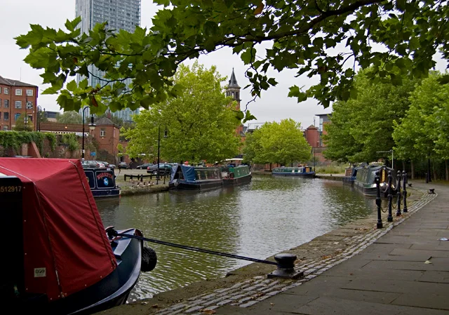
Castlefield’s canal basin, photographed in August 2011.
Castlefield canal basin, Manchester by Paul Harrop · CC BY-SA 2.0. Converted to WebP for faster loading; no cropping.

The cargo still had farther to go
At Castlefield, barges could enter the Merchants and Middle warehouses. Branches of the canal led straight into the buildings, bringing cargo close to storage and horse-drawn carts. Manchester City Council describes this connection between water and road transport.
The canal had delivered the goods to Manchester, but they still needed unloading and sending on. Basins, warehouses and lifting machinery handled those stages. At Grocers Warehouse, water powered machinery that raised coal towards a higher street.
When railway builders arrived, canals and wharves already occupied the ground. They placed railway bridges above the existing waterways. Boats, carts and trains could then carry goods through the same area at different heights.
- Castlefield conservation area — buildings ↗ · reviewed 2026-09-27
- Castlefield conservation area — townscape ↗ · reviewed 2026-09-27
- Historic England — Potato Wharf basin ↗ · reviewed 2026-09-27
Boats entered the warehouses
Branches of the canal let barges enter the Merchants and Middle warehouses. Workers could unload cargo inside and transfer it towards carts. The buildings brought canal transport, storage and road transport close together.
Grocers Warehouse used canal water to power machinery that lifted coal to a higher street. The load could then continue by road. Its surviving or rebuilt features describe a transfer between routes at different heights.
The warehouse was demolished in 1960. The council describes its 1986 rebuilding as partial. It helps explain the old work, but it is not a complete original warehouse. Castlefield includes original remains, altered buildings and rebuilt features.
- Castlefield conservation area — buildings ↗ · reviewed 2026-09-27
Paving for horses and wagons
Potato Wharf has a stone-lined canal branch. Historic England dates it to about 1760–1765. Nearby Giant’s Basin carried overflow water away, helping control the water level as boats used the canal.
Granite setts—small shaped stone blocks—paved the quays. Horses and wagons used them daily, and long wear could round their surfaces. The paving belonged to the handling of cargo, rather than later decoration alone.
When railway builders reached Castlefield, canals and wharves already occupied the ground. They built elevated routes above them. The bridges let another form of transport cross the busy waterfront.
- Historic England — Potato Wharf basin ↗ · reviewed 2026-09-27
- Castlefield conservation area — townscape ↗ · reviewed 2026-09-27
An old box in a later spot
A cast-iron electricity box beside the basin carries Manchester’s crest. It was made to control the power supply. The crest decorated a practical piece of street equipment.
Historic England thinks it was moved here during improvements in the late 1980s. The box is old, but its place beside the basin probably is not original.
- Historic England — Castlefield electricity junction box ↗ · reviewed 2026-09-27
A walk through Castlefield
The National Trust gives a Historic Castlefield Walk. Canal & River Trust describes a Rochdale Canal route. Use those directions rather than joining map pins by the shortest line.
The Rochdale Nine locks lower boats towards Castlefield. Give crews room and follow closure signs. A ground-level walk does not include warehouse interiors or the elevated viaduct garden.
Stay in public areas, leave electrical boxes alone and use the published step-free alternative where needed. We have not checked today’s surfaces or views. On a ground-level walk, the basins and warehouse openings help explain how workers moved cargo from boats towards the city.
- Historic Castlefield Walk ↗ · reviewed 2026-09-27
- Canal walk from Castlefield ↗ · reviewed 2026-09-27
Sources and further reading
Historic England, Manchester City Council, National Trust and Canal & River Trust sources were checked on 27 September 2026. We have not visited or checked access directly. The council’s conservation pages tell the history, not today’s building uses or opening times. The electricity box was probably moved here, but that is not certain. This guide covers ground-level public areas, not private warehouses or entry to the elevated garden. The 2 place records below give more information.
- Bridgewater Canal Basin At Potato Wharf — 1246959
- Electricity Junction Box in Castlefield canal basin, Manchester — 1475255
You can follow the links to read the original sources. Sources and permissions.